
South Australia
February 2019
The Main Valley & Rockdale Hill Hike was on my list for a number of reasons. Firstly, part of the way around it joins up with the Yurrebilla Trail, the trail I’m currently working my way around, mostly solo, on the weekends. Secondly, I’ve read it described as a “hidden gem” in the Adelaide Hills that involves climbing a waterfall (wait what?). Thirdly, I had driven past the entrance to the Park before and knew it wouldn’t be too much of a drama to drive there by myself.
The hike by itself is a 4.7 km long loop.
There was only 1 car parking spot left by the time I got there, although I may have been able to find a place to pull off to the side of the road heading in if I really had to. I was glad that there were other people out there because this Conservation Park is quite tucked away and I knew this hike was going to be trickier to negotiate than some of the others I’d done.

There was a sign showing the various walks. I crossed the bridge and headed up the Main Valley/Waterfall Hike Track to do the trail in an anti-clockwise direction.

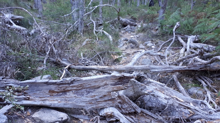
It was quite dark and secluded for this section of the trail. Often the trail was little more than a narrow, rocky creek-bed and there were a lot of blackberry plants with thorns that caught my clothes as I walked through. Looking back behind me it was sometimes hard to see where the trail was that I’d just walked up, and it was mostly uphill.

I have to admit I felt a little unwell. It was difficult to concentrate on my footing and make sure I wasn’t walking through head-height spider webs at the same time. I wanted to rush this section of the trail and get it finished with, but I also didn’t want to twist my ankle because it would be very difficult to hobble back down the track by myself due to all the rocks and being halfway up the side of a hill.
I couldn’t wait to get to the waterfall – even though I knew it wouldn’t have any water. Getting up the waterfall was tough and I was still very aware that I was alone and couldn’t afford to hurt myself. Eventually I made it up (glad that no one could see how ridiculous I probably looked hauling myself up and over the slabs of rock).

The view down was great but I can’t for the life of me see how you could do this when the water was flowing. Even off to the side it would be slippery.
Still more uphill, rocky narrow trail after the waterfall and then finally I hit upon the Mt Lofty/Norton Summit Track. The Yurrebilla Trail and Heysen Trail follow this track.

I got off the loop hike and walked South to Gate 3 – I’m glad I did because it was the perfect spot to sit in the shade to catch my breathe.

Then back up I went, following the trail North. This was also quite a tough section. It was pretty in parts, but got narrow, rocky and undulating once again.

Finding my turnaround point was easy because the narrow trail reached a T-junction – I came out at onto a wide fire track and saw the Giles Conservation Park sign.

I turned around and began the uphill slog back, this time taking the Rockdale Hill Hike trail to complete the loop back to the carpark. This was much nicer and a relief because I was a bit stressed and tired by now.
And then the highlight of my walk. …I finally got to see one of these guys!

I couldn’t believe it. He (or she) was curled into a ball at the base of a tree just off the side of the track. He would have easily been 40cm long, which was much bigger than I expected. I started talking to him and he poked his head out and looked at me, sniffing the air. You might say I’m easily pleased, but this just absolutely made my day.
After a couple of minutes of watching each other he turned around and started waddling away – not scared and not in a hurry.
I was on cloud 9 heading back to the car.
I used the Avenza app on my phone for the first time on this walk. It was brilliant and saved me 2 wrong turns. On the map below you can see the loop on the Western side which is the Main Valley/Rockdale Hill Hike. You can see I extended the hike by going further South a little and then further North (to complete more of the Yurrebilla Trail) before turning around and retracing my steps for a few km’s to join the loop again.
So the loop on it’s own is 4.7 km and I extended it by about another 3 or so km.

I personally wouldn’t choose to do this hike on a hot day (snakes) or after a lot of rain (slippery and not safe getting up the waterfall or the side of the waterfall). I saw about 8 other hikers but no other wildlife other than the echidna. It turned out okay doing it solo, however I did question my sanity a couple of times.
Sarina
Other walks on the Yurrebilla Trail that I’ve completed so far:
Third Falls to Norton Summit, Morialta Conservation Park
Hiker’s Hill – Morialta Conservation Park
Deep View Lookout to Moores Track, Morialta Conservation Park
Deep View Lookout to Third Falls – Morialta Conservation Park
Black Hill Summit Hike – From the Other Side

🙂 That sounds like quite a hike! Your echidna pic didn’t load for some reason, but you made me want to see one and I looked it up. They’re adorable.
LikeLiked by 1 person
Thank you Nora ..I might edit the post, maybe add the echidna photo again x
LikeLike
I love echidnas! I love all Australian mammals because they are so different than North America, but echidnas are one of my favorites.
LikeLiked by 1 person
Ive been wanting to see one in the wild for ages…always seeing other people’s photos. I wasnt disappointed, he was lovely.
LikeLike
Interesting hike! Seeing the echidna would have made my day too!
LikeLiked by 1 person
Is the App you used just for hikes?
LikeLiked by 1 person
Its like an online map store. So you download maps & can then use them offline. Most of the Conservation Parks here seem to have their maps available on there, so you can clearly see all the walking trails. I guess it could be used for trail running as well. Im not sure what other uses though. You can save photos as well but I havent used that feature 😀
LikeLike
Thank you for sharing this hiking trail. So much more in the Adelaide Hills that I didn’t know existed. Will check this track out and hike it some time.
LikeLiked by 1 person
That was really informative. You were lucky it wasn’t hot, if you did it in Feb. I’m curious about the avenza app, which I’ve used for morialta. It gave me a general idea of where I was but I found it hard to work out which trail to use, going forward. Is there something else I should be doing? The map was very small.
LikeLiked by 1 person
When using Avenza, are you tracking your walk? I have an android phone. I open the map, make sure the blue dot is showing on the map where I’m standing and then swipe up from the bottom. Select the heading TRACKING and then select “Start Tracking”. I select this before I start walking and then it records in orange where I’ve walked. At any time I can see if I’ve started heading down the wrong trail. That’s the mean feature I’ve used & it’s been perfect for me – I haven’t explored the rest of the features yet (Navigating to a destination etc).
LikeLike
Oh thanks. I’ll try it with the walk you did, as that sounds great as long as it hasn’t been raining.
LikeLiked by 1 person
That’s great. Hope it goes well.
LikeLike